
Investigation reveals the extensive spread of PFAS “forever chemicals” across Europe, visualized through an interactive map based on unprecedented data collection.
The Forever Pollution Map, a collaborative effort by Le Monde and 17 media partners as part of the cross-border Forever Pollution Project, presents the first comprehensive visual representation of per- and polyfluoroalkyl substances (PFAS) contamination across Europe. These man-made chemical compounds, known as “forever chemicals” due to their environmental persistence, are widely used in numerous industrial and consumer products, posing long-term risks to both the environment and human health. This interactive map highlights the alarming scale of PFAS pollution, a legacy that will impact generations to come.
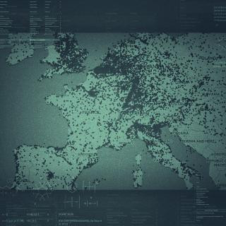 PFAS Contamination Across Europe
Understanding the Scope of PFAS Contamination in Europe
This groundbreaking Europe PFAS contamination map categorizes different types of sites to illustrate the multifaceted nature of this pollution crisis:
- PFAS Production Sites (20): These are chemical manufacturing plants responsible for the synthesis of PFAS chemicals. These facilities are primary sources of PFAS release into the environment.
- Detected PFAS Contamination Sites (23,000+): These locations have undergone environmental sampling, revealing PFAS concentrations in water, soil, or living organisms at or above 10 nanograms per liter (ng/L) between 2003 and 2023. This vast number underscores the widespread reach of PFAS pollution.
- PFAS User Sites (232): Industrial facilities that utilize PFAS in the production of various goods, including high-performance plastics, paints, varnishes, pesticides, and waterproof textiles. Their operations contribute to the dispersal of PFAS into the environment.
- Presumptive PFAS Contamination Sites (21,500+): Locations with documented industrial activities known to use and potentially release PFAS. Military bases, known for their use of PFAS-containing firefighting foams, and fluoropolymer manufacturing plants are examples. While not yet confirmed by sampling, these sites are considered highly likely to be contaminated.
- PFAS Hotspots (2,300+): Areas where PFAS concentrations exceed 100 ng/L, a level considered hazardous by experts. To avoid overcounting due to dense sampling around heavily polluted sites, geographically close points are grouped into “clusters,” providing a more accurate representation of distinct hotspot locations across the Europe PFAS map.
Decoding the Forever Pollution Project Data
The data underpinning this Europe PFAS contamination map is the result of an unprecedented data aggregation effort, combining publicly available information with previously undisclosed data sources. This rigorous approach allowed for the identification of both confirmed and presumptive contamination sites. The methodology employed to identify presumptive sites is adapted from research conducted by the PFAS Project Lab in the United States, ensuring a robust and peer-informed approach to mapping PFAS contamination.
This “Map of Forever Pollution” serves as a critical resource for public awareness, providing crucial data for affected communities, researchers, and regulatory bodies. By visualizing the extent of Europe’s PFAS problem, the map aims to encourage prioritization of sampling campaigns and the development of targeted action plans to safeguard public health and mitigate environmental damage.
It is important to acknowledge that the Europe PFAS contamination map represents the most comprehensive picture to date, but it is still likely an underestimation of the true scale of the problem. Limited environmental testing across European countries means that many contamination sites remain undetected. The number of identified sites is influenced by the extent of testing efforts in each region, highlighting the need for more consistent and comprehensive monitoring across Europe.
Data Accessibility and Continued Research
The Forever Pollution Project is committed to data transparency and reusability. The complete dataset used to create the Europe PFAS contamination map, including geolocation data and sources, is publicly available for download. For in-depth research, a more detailed dataset with PFAS sampling values and comprehensive source information is also accessible.
Furthermore, the CNRS (French National Centre for Scientific Research) has launched the PFAS Data Hub project, building upon the Forever Pollution Project’s data. This initiative provides a regularly updated and expanded inventory of PFAS contamination data, furthering research and understanding of this persistent environmental challenge.
Download the Data:
This Europe PFAS contamination map and the associated data resources serve as a crucial call to action. Understanding the scope and sources of PFAS pollution is the first step towards effective mitigation and remediation efforts to address this “forever pollution” crisis impacting Europe and its environment.